Experimenting with the Web in times of crisis
Local media opens neighborhood forums
The New Orleans Times-Picayune Web site started forums for all neighborhoods, where people post information on the status of the flood and try to connect with lost relatives and friends. The Sun Herald in South Mississippi has a guestbook for remembering victims of the hurricane and town-by-town damage reports.
Craigslist turns its community format to Katrina
In the aftermath of the hurricane, online classifieds giant craigslist.org became a gathering place for people looking for family members or offering help. The site flagged the affected cities in red and created special classffieds categories such as “temporary housing,” “volunteer listings” and “lost and found.” Here are examples from the New Orleans and Mobile sites.
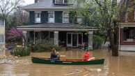
Amateur photographers document the crisis
The Yahoo!-owned photo service Flickr allows users to sort through thousands of images by looking for “tags,” or key words associated with the photographs. The mostly-amateur images are snapped using digital cameras and sometimes cell phones. Click here for photos tagged “hurricanekatrina” or click here to view all “hurricane” related photo pools.
Networks and cable channels offer free video
News-seekers converging on the Internet for up-to-date information found readily available video from the major networks and cable channels. MSN video carried free segments of NBC’s Nightly News as well as reports from MSNBC. CNN also offered free video, as did FoxNews. WWL TV, the CBS affiliate in New Orleans, has offered live streaming video coverage since Katrina hit.
Blog aggregators serve as launching pads
When scores of blogs offer coverage and commentary on the hurricane, it’s not easy to find the right ones. Aggregators such as Truth Laid Bear or blog-portal Technorati keep track of Katrina-related posts from thousands of blogs. Truth Laid Bear even sorts them in two categories: “latest news” and “most linked.”
Katrina WikiHelp Portal
Using the WiKi open source technology that allows users to modify each others’s posts, thus building on previous content, Wikipedia modeled this resource page based on its tsunami Wiki.
Maps and images track storm
Sites have flocked to provide weather maps and satellite images to allow a broad-picture image of the effects of the storm. Global SecurityNational Oceanic and Atmospheric Association. Using Google technology, Scipionus allows users to add markers to streets on the Gulf Coast with comments on their status after the flood. carries satellite images of New Orleans before and after the hurricane. Weather maps and images of Katrina can also be seen at
Interactive graphics show damage
The New York Times makes use of graphics to show how the flood breached the New Orleans levees. The Washington Post carries a NASA simulation of the city under water.